


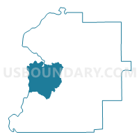
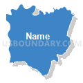
Myrtlewood, Marengo County, Alabama
About
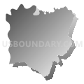
Outline

Summary
| Unique Area Identifier | 522442 |
| Name | Myrtlewood |
| County | Marengo County |
| State | Alabama |
| Area (square miles) | 86.21 |
| Land Area (square miles) | 85.30 |
| Water Area (square miles) | 0.90 |
| % of Land Area | 98.95 |
| % of Water Area | 1.05 |
| Latitude of the Internal Point | 32.22690770 |
| Longtitude of the Internal Point | -87.92522190 |
Maps


Graphs
Select a template below for downloading or customizing gragh for Myrtlewood, Marengo County, Alabama


Neighbors
Neighoring Voting District (by Name) Neighboring Voting District on the Map
- Aimwell, Marengo County, AL
- Jefferson, Marengo County, AL
- Nanafalia, Marengo County, AL
- Old Linden Courthouse, Marengo County, AL
- Pennington-Pelham, Choctaw County, AL
- Sweet Water, Marengo County, AL
Top 10 Neighboring County Subdivision (by Population) Neighboring County Subdivision on the Map
- Demopolis CCD, Marengo County, AL (9,554)
- Linden CCD, Marengo County, AL (4,762)
- Lisman CCD, Choctaw County, AL (3,184)
- Sweet Water CCD, Marengo County, AL (2,088)
Top 10 Neighboring Place (by Population) Neighboring Place on the Map
Top 10 Neighboring Unified School District (by Population) Neighboring Unified School District on the Map
- Choctaw County School District, AL (13,859)
- Marengo County School District, AL (8,822)
- Linden City School District, AL (4,722)
Top 10 Neighboring State Legislative District Lower Chamber (by Population) Neighboring State Legislative District Lower Chamber on the Map
Top 10 Neighboring State Legislative District Upper Chamber (by Population) Neighboring State Legislative District Upper Chamber on the Map
Top 10 Neighboring 111th Congressional District (by Population) Neighboring 111th Congressional District on the Map
Top 10 Neighboring Census Tract (by Population) Neighboring Census Tract on the Map
- Census Tract 9730, Marengo County, AL (4,762)
- Census Tract 9734, Marengo County, AL (4,319)
- Census Tract 9567, Choctaw County, AL (3,184)
- Census Tract 9733, Marengo County, AL (2,088)
Top 10 Neighboring 5-Digit ZIP Code Tabulation Area (by Population) Neighboring 5-Digit ZIP Code Tabulation Area on the Map
- 36732, AL (8,395)
- 36748, AL (3,260)
- 36782, AL (2,405)
- 36916, AL (709)
- 36922, AL (656)
- 36763, AL (139)